Stellar AfricaGold - District-Scale Soil Sampling Defines First Gold Exploration Target At Zuenoula, Cote D'ivoire
(TheNewswire)
Vancouver, BC – February 4, 2026 – TheNewswire - Stellar AfricaGold
Inc. (“Stellar” or the “Company”)
provides the following update on the exploration progress at the
Stellar-MetalsGrove Joint Venture Zuénoula Gold Project, Cote
d’Ivoire.
Highlights
• District-scale
soil sampling (1km by 1km) defines first gold exploration target on
Zuénoula.
• 13 km2 area to
be infilled with higher density sampling (400m by 400m) to define the
centre of gold anomalism and trend of mineralisation.
• Innovative
PortablePPB field assay lab established in nearby town of Zuénoula to
facilitate rapid analysis of MGA samples
• Field sampling
commenced 10 January and 200 of the planned initial 320 (1km by 1km)
soil samples already collected
• Gold anomalous
cluster is located within an interpreted NE-trending belt of mafic
volcanic rocks on the NW-side of an interpreted small granite
intrusion
• Second SEMS
Exploration sampling crew being mobilised to further increase sampling
capacity
Stellar-MetalsGrove
Joint Venture Zuénoula Gold Project, Cote d’Ivoire.
The Stellar-MetalsGrove
Zuénoula Gold Project is a joint venture exploration project between
Stellar’s Ivorian subsidiary Aucrest SARL (“Aucrest”) and
MetalsGrove Mining Ltd. subsidiary, MetalsGrove CDI Pty Ltd
(MetalsGrove) to advance Stellar’s 395.78 square kilometer
early-stage exploration permit called the in Côte d’Ivoire.
Pursuant to the joint venture agreement project operator MetalsGrove
may earn up to a 50% interest in the Zuénoula Gold Project by
incurring US$3,000,000 in exploration expenditures and up to an 80% interest in the Zuénoula Gold Project by
incurring a total of US$6,000,000 in exploration expenditures.
(For further details of the Stellar-MetalsGrove
Joint Venture Agreement see Stellar news release December 9,
2025.)
Stellar Management
Commentary
Stellar President and
CEO J. François Lalonde commented:
“We are pleased with the rapid commencement of exploration by
MetallsGrove at the Zuénoula Gold Project and with the early
indications of anomalous gold in the soil sampling. I extend our
thanks to the MetalsGrove team on the fast start to 2026
exploration.”
MetalsGrove Management
Commentary
MetalsGrove Managing
Director and CEO, Mr Lijun Yang, commented:
“These initial results
are a great start to our 2026 field season and the application of the
innovative PortablePPB assay technology eliminated the usual time
delay between sample collection, receipt of assays, and the
implementation of follow-up in-fill soil sampling. I am also pleased
that SEMS has additional capacity to mobilise a second sampling crew
to Zuénoula to further increase our rate of sampling.”
“The Zuénoula permit
lies in an exploration corridor with favourable geological
characteristics, including mixed volcanic and metasediment
lithological sequences, complex structural features, and active
artisanal workings, all of which are strong indicators of gold
discovery potential.”
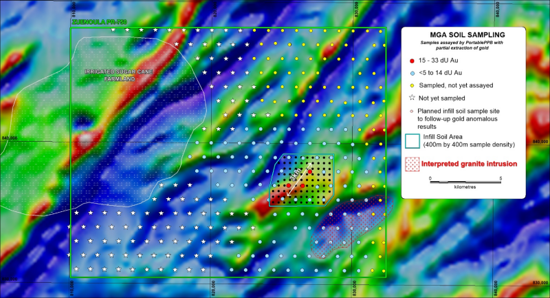
Zuénoula Soil Sampling
Update
Stellar is pleased to
announce that initial sampling on Stellar-MetalsGrove Zuénoula Gold
Project has defined a significant cluster of three 1km by 1km spaced
gold anomalous (15 to 33 dU) soil samples coincident with a
NE-trending magnetic feature interpreted to reflect a mafic volcanic
unit intruded by an elongated granite.
Field work at Zuénoula
commenced four weeks after the Stellar-MetalsGrove JV agreement was
signed, and of the initial 320 broadly-spaced (1km by 1km) soil
samples planned, 200 have been collected and 124 assayed, with further
assays to be received within the coming days. A further 90 infill
samples over 13 km2 are to be collected on 400m by 400m centres to
follow-up the initial gold anomalous cluster of three soil samples.
Further infill will then be initiated to a point that will facilitate
the effective sighting of drill holes.
Click Image To View Full Size
Figure 1. Map
illustrating progress of soil sampling on Zuénoula permit and the
location of the recently defined gold anomalous soil cluster (soon to
be infilled) on aeromagnetic (RTP) image
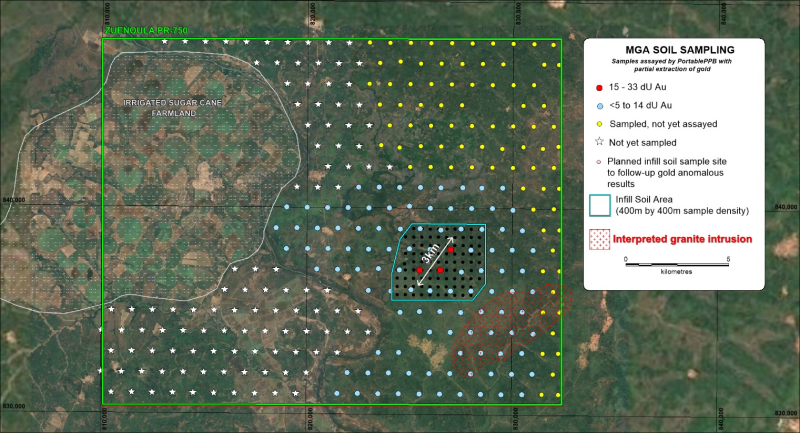
Click Image To View Full Size
Figure 2. Map
illustrating progress of soil sampling on Zuénoula permit and the
location of the recently defined gold anomalous soil cluster (soon to
be infilled) on Google image
QA/QC
JORC Code, 2012 Edition – Table 1
Section 1- Sampling Techniques and Data
(Criteria in this section apply to all succeeding
sections)
|
Criteria
|
JORC Code Explanation
|
Commentary
|
|
Sampling Techniques
|
-
Nature and quality of sampling (e.g. cut channels,
random chips, or specific specialied industry
standard measurement tools appropriate to the minerals under
investigation, such as downhole gamma sondes, or
handheld XRF instruments, etc.) These examples should not be taken as
limiting the broad meaning of sampling.
-
Include reference to measures taken to ensure sample
representivity and the appropriate calibration of any measurement
tools or systems used.
-
Aspects of the determination ofmineralisation that are Material to the Public
Report.
In cases where ‘industry standard’ work has been
done, this would be relatively simple (e.g. ‘reverse circulation
drilling was used to obtain 1 m samples from
which 3 kg was pulverised to produce a 30 g charge for fire assay’).
In other cases, more explanation may be required, such as where there
is coarse gold that has inherent sampling problems. Unusual
commodities or mineralisation types (e.g. submarine nodules) may
warrant disclosure of detailed information.
|
No drilling has been undertaken. The current ASX
announcement presents initial results of a soil geochemical survey
being undertaken on the Zuénoula project PR-750 in Cote
d’Ivoire.
Soil Sampling (PortablePPB): Initial broad-spaced (1km by 1km) soil sampling supported by
rapid field analysis of samples using the PortablePPB analytical
technique is being undertaken so that gold anomalous trends can be
identified and infill sampling conducted to define drill targets
before the field crew is demobilized.
-
The highly professional and experienced consulting
group SEMS Exploration Services has been contracted to conduct soil
sampling and assay the samples using their PortablePPB mobile
laboratory
-
The MGA Exploration Manager was onsite at the start of
the field program to instruct the sampling crew on the Standard
Sampling Procedure required by MGA
-
MGA provided SEMS Exploration Services with an Excel
table listing the designated sample point locations using WGS-84 UTM
zone 29N coordinates
-
Each soil sample is collected from within 100 metres of
the designated sample point, with the actual sample point then
recorded
-
At each sample point: 1) the organic rich soil is
brushed away, 2) a 15cm deep hole is dug and the sample collected by
taking a channel-cut along the entire length of the hole, 3) 800g of
the minus 2mm sieved fraction of each sample is collected from the
sample point, 4) at the field lab in Zuénoula, a hand-held XRF (pXRF)
is used to determine and record arsenic, copper, nickel, tungsten,
iron and manganese concentrations 5) gold is determined using the
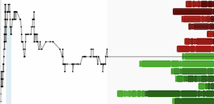
PortablePPB technique and results are reported in dU, an partial extracted gold measurement units
-
Duplicate samples are collected every 20th sample and
given the next sample number
-
No Standards other than instrument calibration
standards are used to avoid low-level gold contamination. Gold
anomalous samples sites (+15dU Au) are to be
re-assayed using the fire assay technique at
MSALabs in Yamoussoukro
-
Samples are processed and stored at the secure SEMS
field laboratory and compound in Zuénoula.
-
Assay results are reported to MetalsGrove within 48
hours so that infill sampling can be planned and scheduled.
|
|
Drilling Techniques
|
-
Drill type (e.g. core, reverse circulation, open-hole
hammer, rotary air blast, auger, Bangka, sonic, etc.) and details
(e.g. corediameter,tripleorstandard
tube,depthofdiamond tails, face-sampling bit or other type, whether core
is oriented and if so, by what method, etc).
|
|
|
Drill Sample Recovery
|
-
Method of recording and assessing core and chip sample
recoveries and results assessed.
-
Measures taken to maximise sample recovery and ensure
representative nature of the samples.
-
Whether a relationship exists between sample recovery
and grade,andwhether
samplebias may have occurred due to preferential
loss/gain of fine/coarsematerial.
|
|
|
Logging
|
-
Whether core and chip samples have been geologically and geotechnicallyloggedtolevel of
detail to support appropriate Mineral Resource estimation,
miningstudiesandmetallurgical studies.
-
Whether loggingisqualitativeor quantitative in nature.
Core (or costean, channel, etc.) photography.
-
Thetotallengthandpercentage oftherelevantintersections logged.
|
-
No drilling has been undertaken.
-
Soil samples are comprehensively logged for a range of
parameters including color, soil horizon, sample weight, slope,
dominant grain size (clay, silt, sand), general topography, residual
or transported, proximity to artisanal workings, other ground
disturbances such as field plowing, and general land use (grassland,
plantation, crop, etc.).
|
|
Sub-sampling Techniques
and Sample Preparation
|
-
Ifcore,whethercutorsawnand whether
quarter, half or all core taken.
-
Ifnon-core,whetherriffled,tube sampled, rotary split, etc. and whether sampled wet or
dry.
-
For all sample types, the nature, quality and
appropriateness of the sample preparation technique.
-
Quality control procedures adopted for all sub-sampling
stagestomaximise
representivity of samples.
-
Measures taken to ensure that thesamplingisrepresentativeof the in-situ material
collected, including, for instance, results for field
duplicate/second-half sampling.
-
Whethersample sizes are appropriate to the grain size of
the material being sampled.
|
-
No drilling has been undertaken.
-
The 800g -2mm soil fraction collected in the field is
riffle split at the field laboratory in Zuénoula into two 400g
sub-samples, with one used for PortablePPB analysis and the other used
for pXRF and fire assay analysis when the PortablePPB determination
equals or exceeds 15dU
|
|
Quality of Assay Data and Laboratory Tests
|
-
The nature, quality and appropriateness of the assaying
andlaboratoryproceduresused and whether the
technique is considered partial or total.
-
Forgeophysical tools,
spectrometers, handheld XRF
instruments,etc.,theparameters used in determining the
analysis, including instrument make and model, reading times,
calibrationfactorsapplied,and
their derivation, etc.
-
Nature of quality control procedures adopted (e.g.
standards, blanks, duplicates, externallaboratorychecks)and whether acceptable levels of accuracy (i.e. lack of bias)
and precision have been
established.
|
-
Samples are analysed using the patented detectORE™
process developed by Portable PPB Pty Ltd in Australia
-
The process involves a partial extraction using the
safe, non-dangerous GLIX-20® reagent that is akin to traditional BLEG
(which uses a cyanide leach)
-
The 400g samples are added to the reagent and tumbled
for 12 hours, into which the detectORE™ collector device had been
inserted
-
After the bottle roll process has completed, the
collector device is removed, washed, and dried prior to reading on a
Vanta M (VMR) pXRF loaded with Evident/Olympus’s detectORE™
mode
-
The entire process is managed using Portable PPB’s
Portable Lab Information Management System (pLIMSTM), which records
all aspects of the sample throughput, including QAQC and control of
the pXRF via the Application Programming
Interface to Olympus/Evident’s co-developed detectORE™ mode.
-
Certified Collector Devices (CCDs) supplied by
PortablePPB with known quantities of gold ranging from 0 -1000 ppb are
used to check that the pXRF was functioning correctly and that the
instrument settings were as intended. One CCD serves as a blank.
-
The pLIMS software confirmed the instrument settings
are correct and the VMR is operating as expected, controlled by the
pLIMS API and Evident’s detectORE™ firmware.
|
|
Verification of Sampling
and Assaying
|
-
The verification of significant intersections by either
independent or alternative company personnel.
-
Theuseoftwinnedholes.
-
Documentationofprimarydata, data entry procedures,
data verification, data storage (physical and electronic) protocols.
-
Discussanyadjustmentstoassay data.
|
-
The detectORE™ process is checked in accordance with
PortablePPB’s recommended processes and procedures. These include
the insertion of 400g reference materials (RMs).
-
The RMs comprise mixtures of commercial Certified
Reference Materials (CRMs) and barren regolith material. The RMs are
of known, but uncertified gold concentration and are used to check
that the leach and collect process has worked as intended during the
12-hour bottle roll.
-
RMs were inserted at a rate of 1 every 44 samples
throughout the sample batches. The RMs were checked against Portable
PPB’s cloud-based database and passed within the accepted tolerance
ranges for the technique, currently 20% (3 sigma).
-
The pXRF instrument settings are checked using a range
of Certified Collector Devices, which are used to confirm the pXRF is
operating as expected. The pXRF spectral files are reviewed by
Portable PPB’s cloud and SME procedures.
|
|
Location of Data Points
|
-
Accuracy and qualityof surveys
used to locate drillholes (collar and down-hole surveys), trenches,
mine workings and other locations used in Mineral Resource
estimation.
-
Specification of the grid system used.
-
Quality and adequacy of topographic control.
|
-
A handheld GPS is used to locate the soil data
positions, with a +/-5m vertical and horizontal accuracy
-
Sample locations (UTM WGS84 zone 29N) and sample
descriptions are noted on a standard form in the field and entered
into a computer of an evening
-
GPS measurements of sample positions are sufficiently
accurate for first pass, board-spaced sample collection.
|
|
Data Spacing and Distribution
|
-
Data spacing for reporting Exploration
Results.
-
Whether the data spacing and distribution is sufficient
to establish the degree of geologicalandgradecontinuity appropriate for the Mineral Resource and Ore
Reserve estimation procedure(s) and classifications applied.
-
Whethersamplecompositing hasbeenapplied.
|
-
The 1km by 1km offset soil sample pattern over the
permit area, excluding areas of irrigated sugar cane, is considered an
effective technique for identifying and delimiting gold anomalous
trends, which are then followed up with higher density sampling, with
400m by 400m as the next phase and then further infill as required to
define well constrained drill targets.
|
|
Orientation of data in relation
to geological al
structure
|
-
Whether the orientation of sampling achieves unbiased
sampling of possible structures and the extent to which this is known,
considering the deposit type.
-
If the relationship between the drilling orientation
and the orientation of key mineralised structures is considered to
have introduced a sampling bias, this should be assessed and reported
if material.
|
|
|
Sample security
|
|
|
|
Audits or Reviews
|
|
-
The sampling and assay technique adopted by MetalsGrove
has been effectively used in the Vavoua-Kounahiri district, and more
widely in Cote d’Ivoire, to define drill targets and it is
considered an effective initial approach for defining gold anomalous
lithogeochemical trends.
|
Section 2 - Reporting of
Exploration Results
(Criteria listed in the preceding section also apply to this section.)
|
Criteria
|
JORC Code Explanation
|
Commentary
|
|
Mineral Tenement and Land
Tenure Status
|
-
Type, reference name/number, location and ownership,
including agreements or material issues with third parties such as
joint ventures, partnerships, overriding royalties, native title
interests, historical sites, wilderness or national park and
environmental settings.
-
The security of the tenure held at the time of
reporting, along with any known impediments to obtaining a licence to
operate in the area.
|
-
Following the acquisition of the three Gemica joint venture (JV) permits in
Côte d’Ivoire, MetalsGrove entered into another JV with TSX-V
listing company Stellar AfricaGold Inc. (Stellar) for its PR-750
Zuénoula permit. PR-750 was granted on 17 April 2024 for an initial
four-year period, renewable for two additional three-year periods.
-
The Zuénoula permit is located between existing MetalsGrove controlled Kounahiri West and Vavoua
permits along the same Birimian greenstone belt. The two groups of
joint venture permits (4) occupy a combined area of 1,315 km²,
strategically situated along the Abujar–Napie gold trend within the
Oumé–Fetekro Birimian greenstone belt in central west of Côte d’Ivoire,
approximately 100 km north of the Abujar gold mine and 160 km south of
the Napie gold project.
|
|
Exploration Done by Other Parties.
|
|
|
|
Geology
|
|
-
The Zuénoula permit (Stellar JV), together with the
Vavoua, Vavoua West, and Kounahiri West permits
acquired through the Gemica JV, are in the
central west of Côte d'Ivoire at the south edge of the West
Africa craton. This region is the world’s largest Proterozoic
gold-producing region, and Cote d’Ivoire contains 35% of the
region’s Birimian Group rocks, which host multiple
multi-million-ounce gold deposits.
-
The Gemica JV permits and Stellar JV permit, together cover a combined
area of 1,315 km², and are strategically situated along the
Abujar–Napie gold trend within the Oumé–Fetekro Birimian
greenstone belt, and are located approximately 100 km north of the
Abujar gold mine and 160 km south of the Napie gold project.
|
|
Drillhole Information
|
-
A summary of all information material to the
understanding of the exploration results, including a tabulation of
the following information for all Material drill holes:
-
easting and northing of the drillhole collar elevation
or RL (Reduced Level – elevation above sea level in metres) of the
drillhole collar dip and azimuth of the hole
-
down hole length and interception depth hole
length.
|
|
|
Data Aggregation Methods
|
-
In reporting Exploration Results, weighting averaging
techniques, maximum and/or minimum grade truncations (e.g., cutting of
high grades) and cut-off grades are usually Material and should be stated.
-
Where aggregate intercepts incorporate short lengths of
high-grade results and
longer lengths of low-grade results, the procedure used for such aggregation should be
stated, and some typical examples of such aggregations should be shown
in detail.
-
The assumption used for any reporting of metal
equivalent values should be clearly stated.
|
|
|
Relationship Between
Mineralisation Widths and
Intercept Lengths
|
|
|
|
Diagrams
|
-
Appropriate maps and sections (with scales) and
tabulations of intercepts should be included for any significant
discovery being reported. These should include, but not be limited to,
a plan view of drillhole collar locations and appropriate sectional
views.
|
|
|
Balanced Reporting
|
-
Where comprehensive reporting of all Exploration
Results is not practicable, representative reporting of both low and
high grades and/or widths should be practied, avoiding misleading reporting of Exploration Results.
|
|
|
Other Substantive Exploration Data
|
-
Other exploration data, if meaningful and material,
should be reported, including (but not limited to): geological
observations; geophysical survey results; geochemical survey results;
bulk samples – size and method of treatment; metallurgical test
results; bulk density, groundwater, geotechnical and rock
characteristics; potential deleterious or contaminating
substances.
|
|
|
Further Work
|
-
The nature and scale of planned further work (e.g.
tests for lateral extensions, or depth extensions, or large-scale
step-out drilling).
-
Diagrams clearly highlighting the areas of possible
extensions, including the main geological interpretations and future
drilling areas, provided this information is not commercially
sensitive.
|
-
The soil sampling program commenced on 10 January 2026
and at the 26 January 2026, 200 samples of the 320 planned
samples had been collected, with 124 assayed for
gold by PortablePPB.
-
Field programs will be sequentially initiated on the
adjoining Gemica JV permits, with PR454 Vavoua next, and the others
once tenure is granted by the Government of Cote d'Ivoire
-
The images included show the location of the soil
sample sited (planned and sampled) for the current field
program.
|
Qualified Person
The technical information contained in this release has
been reviewed and approved by Mr Robert Perring, a current member of
the Australian Institute of Geoscientists (MAIG) and Exploration
Manager of MetalsGrove Mining Limited. Mr Perring is a Qualified Person under National
Instrument 43-101.
About Stellar Africagold Inc.
Stellar AfricaGold Inc. is a Canadian precious metal
exploration company focused on precious metals
in North and West Africa, with active programs in
Morocco and Côte d’Ivoire. Stellar’s principal exploration
projects are its advancing gold discovery at the Tichka Est Gold
Project in Morocco, and its
early-stage exploration Zuénoula Gold Project in Côte
d’Ivoire which is operated in Joint venture with MetalsGrove Mining
Ltd subsidiary, MetalsGrove CDI Pty Ltd.
The Company is listed on the TSX Venture Exchange
symbol TSX.V: SPX, the Tradegate Exchange TGAT: 6YP and the Frankfurt
Stock Exchange FSX: 6YP.
The Company maintains its head office in Vancouver, BC
and has a country office in Marrakech, Morocco.
Stellar’s President and CEO J. François Lalonde can
be contacted at +1 514-9940654 or by email at lalondejf@stellarafricagold.com
Additional information
is available on the Company’s website at www.stellarafricagold.com.
On Behalf of the Board
J. François Lalonde
President & CEO
This news release
contains “forward-looking statements” within the meaning of
applicable Canadian securities laws, including statements regarding
the grant of PSUs, the potential vesting of such PSUs upon the
achievement of future production milestones, the issuance of common
shares of the Company upon settlement of vested PSUs, and the
acceptance of the TSX Venture Exchange.
Forward-looking
statements are based on expectations, estimates and projections as at
the date of this news release and are subject to known and unknown
risks, uncertainties and other factors that may cause actual results
or events to differ materially from those expressed or implied. Such
risks and uncertainties include, but are not limited to, the Company
not achieving the production milestones described herein, changes in
business plans or commodity prices, failure to
obtain regulatory approvals, and the risk factors described in the
Company’s most recent Management’s Discussion and Analysis and
Annual Information Form, which are available on SEDAR+ at www.sedarplus.ca.
Forward-looking
statements are not guarantees of future performance and should not be
unduly relied upon. Except as required by law, the Company undertakes
no obligation to update or revise any forward-looking statements
contained herein.
Neither the TSX Venture
Exchange nor its Regulation Services Provider (as that term is defined
in the policies of the TSX Venture Exchange) accepts responsibility
for the adequacy or accuracy of this release.
Copyright (c) 2026 TheNewswire - All rights reserved.