VANCOUVER, British Columbia, Oct. 08, 2024 (GLOBE NEWSWIRE) -- VR Resources Ltd. (TSX.V: VRR, FSE: 5VR; OTCBB: VRRCF), the "Company", or “VR”, is pleased to announce the acquisition of the Rambler Gold Project (“Rambler”), located approximately 6km north of VR’s Empire Project on Trans Canada Highway 17 in Ontario, and has submitted a permit application for drilling and trenching.
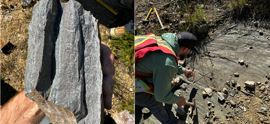
Rambler was staked because sulfides reported in historic drill logs have been discovered at surface (Photo 1). In 1968, Inco drilled 5 holes at Rambler to less than 50m each, targeting EM anomalies for base metal mineralization, and intersected massive sulfide in each hole, with up to 6m of 85% pyrrhotite-pyrite around a magnetic high (Figure 1). As was common at the time, however, assays for gold were not completed or reported.
Recent sampling by VR shows anomalous gold in every rock unit at Rambler, and up to 149 ppb in disseminated pyrrhotite from mafic volcanic outcrops exposed during forestry road building in 2016, and subsequent prospecting by Holbik Exploration. Disseminated pyrrhotite (a magnetic iron sulfide) occurs in zones of silicification of both metavolcanics and arenite, peripheral to magnetic highs. VR has now recognized east-west shearing and boudinage on the south limb of a northeast-striking fold hinge at Rambler, which is adjacent to the Marmion fault that transects the Hammond Reef gold deposit to the southwest.

Photo 1. Like the Empire Project to the south, outcrops are sparse at Rambler. Gold mineralization in meta-volcanic rocks examined by VR Resources on Sept. 25th, 2024, occurs in outcrops exposed by forestry road building in 2016. Anomalous gold is correlated with disseminated and veinlet sulfides found in the foliated and sheared chlorite schists, with an apparent east-west and northeast structural control.
From VR’s CEO Justin Daley: “We’re excited about the early gold potential at Rambler, which became apparent during our compilation of historic data for the Empire District. Due to limited exposure of the North Lumby Lake greenstone belt in this area, the region saw little exploration in the 1960s, which was focused on massive sulfide nickel-copper models. While we remain focused on our exploration at Empire and Silverback which are currently permitted for drilling, the addition of the Rambler target gives VR a quick drill test on known massive sulfides, with obvious program synergies with Empire. The exploration permit for Rambler is expected within 30 to 60 days, allowing us to twin the 1968 Inco holes in order to document for the first time the gold and polymetallic grade potential of the massive sulfide mineral system.”
About the Rambler Project
The Project consists of 4 multi-cell mineral claims in 1 contiguous block spanning 6.5 by 5.5 km and covering 2,085 hectares. Rambler is located on Federal crown land, with mineral rights administered by the provincial Ontario Ministry of Mines. There are no annual payments, but the Province requires certain annual exploration expenditures and reporting (ie. mineral assessment reports) in order to maintain a mineral claim in good standing. The Project falls within the Lac de Mille Lac First Nation traditional territories.

Figure 1. Location of recently staked Rambler Project, just 6km north of the Empire Project which straddles the Trans-Canada Highway 17, some two hours west of Thunder Bay, Ontario. Historic sulfide intervals from drilling in 1968 is shown atop a basemap of coarse regional magnetic data with important faults and greenstone belts from OGS mapping. Gold assays are from VR Resources, from samples taken two weeks ago from outcrops recently exposed by logging in the area.
Technical Information
Surface grab samples were submitted for geochemical analysis to the AGAT laboratory in Thunder Bay, Ontario. Sample preparation is completed in Thunder Bay alongside gold and PGE determination by atomic absorption assay. ICP-MS analyses for base metals and trace elements is performed at AGAT’s laboratory in Calgary, AB. Analytical results are subject to industry-standard and NI 43-101 compliant QAQC sample procedures, including the systematic insertion of sample duplicates, blanks and certified reference material (CRM) done both externally and internally at the laboratory by AGAT, as described by AGAT.
Technical information for this news release has been prepared in accordance with the Canadian regulatory requirements set out in National Instrument 43-101. Justin Daley, P.Geo., President and CEO at VR and a non independent Qualified Person oversees and/or participates in all aspects of the Company’s mineral exploration projects, and the content of this news release has been reviewed on behalf of the Company by the Executive Chairman, Dr. Michael Gunning, P.Geo., a non-independent Qualified Person.
About VR Resources
VR is an established junior exploration company based in Vancouver (TSX.V: VRR; Frankfurt: 5VR; OTCQB: VRRCF). VR evaluates, explores and advances large-scale, blue-sky opportunities in copper, gold and critical metals in Nevada, USA, and Ontario, Canada, and more recently, Canada’s newest discovery of a diamond-bearing kimberlite pipe at its Northway project. VR applies modern exploration technologies and leverages in-house experience and expertise in greenfields exploration to large-footprint mineral systems in underexplored areas/districts. The foundation of VR is the proven track record of its Board in early-stage exploration, discovery and M&A. The Company is financed for its mineral exploration and corporate obligations. VR owns its properties outright and evaluates new opportunities on an ongoing basis, whether by staking or acquisition.
ON BEHALF OF THE BOARD OF DIRECTORS:
“Justin Daley”
Justin Daley, MSc, PGeo
President & CEO
For general information please use the following:
| Website: | www.vrr.ca | |
| Email: | info@vrr.ca | |
| Phone: | 778-731-9292 | |
Forward Looking Statements
This news release contains statements that constitute "forward-looking statements". Such forward looking statements involve known and unknown risks, uncertainties and other factors that may cause the Company’s actual results, performance or achievements, or developments in the industry to differ materially from the anticipated results, performance or achievements expressed or implied by such forward-looking statements. Forward-looking statements are statements that are not historical facts and are generally, but not always, identified by the words "expects," "plans," "anticipates," "believes," "intends," "estimates," "projects," "potential" and similar expressions, or that events or conditions "will," "would," "may," "could" or "should" occur. Forward-looking statements in this document include statements concerning VR’s plans for new geophysical surveys and drilling on the newly acquired properties this fall, and all other statements that are not statements of historical fact.
Although the Company believes the forward-looking information contained in this news release is reasonable based on information available on the date hereof, by their nature forward-looking statements involve assumptions, known and unknown risks, uncertainties and other factors which may cause our actual results, performance or achievements, or other future events, to be materially different from any future results, performance or achievements expressed or implied by such forward-looking statements.
Examples of such assumptions, risks and uncertainties include, without limitation, assumptions, risks and uncertainties associated with general economic conditions; adverse industry events; future legislative and regulatory developments in the mining sector; the Company’s ability to access sufficient capital from internal and external sources, and/or inability to access sufficient capital on favorable terms; mining industry and markets in Canada and generally; the ability of the Company to implement its business strategies; competition; and other assumptions, risks and uncertainties.
The forward-looking information contained in this news release represents the expectations of the Company as of the date of this news release and, accordingly, is subject to change after such date. Readers should not place undue importance on forward-looking information and should not rely upon this information as of any other date. While the company may elect to, it does not undertake to update this information at any particular time except as required in accordance with applicable laws.
This news release may also contain statements and/or information with respect to mineral properties and/or deposits which are adjacent to and/or potentially similar to the Company’s mineral properties, but which the Company has no interest in nor rights to explore. Readers are cautioned that mineral deposits on similar properties are not necessarily indicative of mineral deposits on the Company’s properties.
Trading in the securities of the Company should be considered highly speculative. All of the Company’s public disclosure filings may be accessed via www.sedarplus.ca and readers are urged to review them.
Neither the TSX Venture Exchange nor its Regulation Services Provider (as that term is defined in Policies of the TSX Venture Exchange) accepts responsibility for the adequacy or accuracy of this release
Photos accompanying this announcement are available at
https://www.globenewswire.com/NewsRoom/AttachmentNg/15a4f355-dbd1-4a49-a01d-31d83cb8d4b4
https://www.globenewswire.com/NewsRoom/AttachmentNg/abdd11b9-8204-4932-b7bb-919860f56019


