


VANCOUVER, British Columbia, Feb. 01, 2023 (GLOBE NEWSWIRE) -- Regulus Resources Inc. ("Regulus" or the "Company", TSX-V: REG, OTCQX: RGLSF) is pleased to report the remaining drilling results from its phase two drilling program at the AntaKori copper-gold project in Peru. Reported herein are the final seven drill holes from the 2022 drill program, AK-22-053 through AK-22-059. Holes AK-22-053 and AK-22-055 were designed to test portions of the Colquirrumi claims (currently owned by Buenaventura) where Regulus can earn up to a 70% interest in the claims by completing 7,500 m of drilling. With this drilling, the threshold has been met and Regulus has notified Buenaventura. Buenaventura now has a one-time right until February 22, 2023, to either give Regulus a 70% interest in the claims or give Regulus a 30% interest in the claims and a cash payment of US$9 million. If Regulus receives a 30% interest, it still retains open-pit layback rights on the Colquirrumi claims. Holes AK-22-054, AK-22-057 and AK-22-059 were designed to expand the mineralized footprint of the AntaKori deposit to the north and east of current drilling. Holes AK-22-056 and AK-22-058 were designed to fill in a gap in the current resource.
Highlights
Holes AK-22-053 and AK-22-055
- These holes were designed to test the Colquirrumi claims to the east of currently defined mineralization and to complete meterage towards the earn-in agreement
- Regulus has now completed all the necessary drilling on the Colquirrumi claims to trigger the earn-in. Buenaventura has until February 22, 2023 to decide as to whether they will give Regulus a 70% interest in the claims or claw-back by giving Regulus a 30% interest in the claims and paying US$9 M.
- Mineralization was relatively weak in both holes
Hole AK-22-054
- 128.15 m of 0.08% Cu, 0.30 g/t Au and 3.87 g/t Ag from 383.15 m depth
- 87.68 m of 0.34% Cu, 0.41 g/t Au and 8.62 g/t Ag from 541.10 m depth
- 80.49 m of 0.22% Cu, 0.18 g/t Au and 2.98 g/t Ag from 663.74 m depth
- 68.00 m of 0.20% Cu, 0.08 g/t Au and 1.32 g/t Ag from 827.00 m depth
- Hole 54 extended the mineralized footprint significantly to the north of existing resources and opened an area for future drilling
Hole AK-22-056
- 403.55 m of 0.25% Cu, 0.18 g/t Au and 7.38 g/t Ag from 118.75 m depth
- 323.25 m of 0.49% Cu, 0.11 g/t Au and 6.30 g/t Ag from 811.75 m depth
- Including 109.65 m of 0.71% Cu, 0.15 g/t Au and 4.08 g/t Ag from 935.00 m depth
- The hole ended in mineralization
- Hole 56 returned multiple long runs of mineralization similar to previously completed holes to the east and west
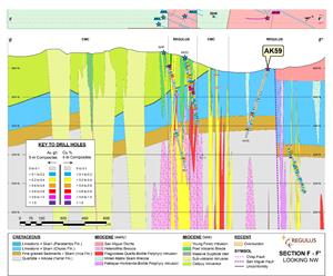
Hole AK-22-057
- 87.50 m of 0.11% Cu, 0.23 g/t Au and 3.26 g/t Ag from 180.30 m depth
- 65.20 m of 0.19% Cu, 0.10 g/t Au and 3.86 g/t Ag from 308.70 m depth
- Hole 57 encountered spotty mineralization indicating the mineralized footprint is weakening to the northeast of the project
Hole AK-22-058
- 240.55 m of 0.38% Cu, 0.26 g/t Au and 7.05 g/t Ag from 388.95 m depth
- Including 185.05 m of 0.44% Cu, 0.26 g/t Au and 6.97 g/t Ag from 444.45 m depth
- Hole 58 interested mineralization as expected with similar grades to drilling completed to the east and west
Hole AK-22-059
- 26.50 m of 0.18% Cu, 0.66 g/t Au and 8.34 g/t Ag from 317.70 m depth
- Similar to Hole 57, Hole 59 encountered spotty mineralization indicating the mineralized footprint is weakening to the northeast of the project
John Black, Chief Executive Officer of Regulus, commented as follows:
"We have now completed our phase two drill program at the AntaKori project. The holes reported today demonstrate that the mineralized footprint expands well beyond the current resource estimate at AntaKori and that mineralization remains open in several directions. With the phase two drill program complete, we will transition to a resource estimate update that we expect to be completed in H2-2023. To date, the Company has focused on increasing the size of the mineral resource at AntaKori with significant success. As part of our recently announced strategic investment from Nuton (a division of Rio Tinto), we will begin to evaluate the potential of their sulphide leaching technology on mineralization at AntaKori as well as shift towards focusing on early feasibility work to define the best options for development of the project. We have stopped drilling at AntaKori during the rainy season which typically ends by April. During the downtime, we will evaluate the best pathway forward to further enhance or expand resources and commence activities to best position the AntaKori project for development."
Dr. Kevin B. Heather, Chief Geological Officer of Regulus, commented as follows:
“While the latest drilling results indicate that mineralization remains open to the north and northwest, it now appears that the “porphyry-centre” that we had theorized was located to the north of current resources is most likely located deeper below the current resource area, beyond the limits of the shallow looking geophysics. That being said, we intersected skarn and intermediate sulphidation mineralization well beyond the current limits of the known resources which could present opportunities for future drilling. However, it is important to note that the current resource in-hand at AntaKori, when combined with the neighbouring reported Tantahuatay sulphide resource of Compania Minera Coimolache, already places the “TantaKori” consolidated resource amongst one of the largest undeveloped copper projects with overall high-grade, very low strip ratio, all within a brownfield development scenario.”
Table 1 below provides more details on the mineralized intercepts encountered in holes AK-22-053 through AK-22-059. The location of the reported drill holes is indicated in Figure 1. Figures 2 through 7 display cross sections of the various holes reported herein.
| Table 1 – AntaKori Drill Hole Results | ||||||||
| From (m) | To (m) | Interval (m) | Cu (%) | Au (ppm) | Ag (ppm) | As (ppm) | ||
| AK-22-053 | ||||||||
| Interval | 471.58 | 487.30 | 15.72 | 0.18 | 0.21 | 1.74 | 249 | |
| AK-22-054 | ||||||||
| Interval | 229.50 | 283.00 | 53.50 | 0.16 | 0.23 | 2.15 | 683 | |
| Interval | 316.30 | 335.85 | 19.55 | 0.20 | 0.14 | 4.10 | 169 | |
| Interval | 383.15 | 511.30 | 128.15 | 0.08 | 0.30 | 3.87 | 294 | |
| incl | 494.90 | 511.30 | 16.40 | 0.11 | 0.54 | 13.11 | 830 | |
| Interval | 541.10 | 628.78 | 87.68 | 0.34 | 0.41 | 8.62 | 305 | |
| Interval | 663.74 | 744.23 | 80.49 | 0.22 | 0.18 | 2.98 | 297 | |
| Interval | 780.93 | 804.15 | 23.22 | 0.21 | 0.12 | 2.83 | 283 | |
| Interval | 827.00 | 895.00 | 68.00 | 0.20 | 0.08 | 1.32 | 110 | |
| AK-22-055 | ||||||||
| Interval | 464.60 | 475.30 | 10.70 | 0.20 | 0.12 | 2.99 | 96 | |
| AK-22-056 | ||||||||
| Interval | 118.75 | 522.30 | 403.55 | 0.25 | 0.18 | 7.38 | 177 | |
| incl | 125.00 | 141.93 | 16.93 | 0.43 | 0.19 | 10.09 | 238 | |
| and | 238.80 | 262.55 | 23.75 | 0.41 | 0.26 | 8.26 | 218 | |
| Interval | 811.75 | 1,135.00 | 323.25 | 0.49 | 0.11 | 6.30 | 287 | |
| incl | 935.00 | 1,044.65 | 109.65 | 0.71 | 0.15 | 4.08 | 356 | |
| AK-22-057 | ||||||||
| Interval | 180.30 | 267.80 | 87.50 | 0.11 | 0.23 | 3.26 | 388 | |
| Interval | 308.70 | 373.90 | 65.20 | 0.19 | 0.10 | 3.86 | 99 | |
| Interval | 412.60 | 428.00 | 15.40 | 0.43 | 0.64 | 39.13 | 345 | |
| AK-22-058 | ||||||||
| Interval | 190.25 | 244.00 | 53.75 | 0.12 | 0.35 | 5.02 | 1,219 | |
| Interval | 294.85 | 355.65 | 60.80 | 0.31 | 0.24 | 11.38 | 334 | |
| Incl | 320.65 | 340.40 | 19.75 | 0.50 | 0.42 | 14.86 | 486 | |
| Interval | 388.95 | 629.50 | 240.55 | 0.38 | 0.26 | 7.05 | 239 | |
| Incl | 444.45 | 629.50 | 185.05 | 0.44 | 0.26 | 6.97 | 247 | |
| Interval | 804.50 | 831.30 | 26.80 | 0.15 | 0.07 | 0.92 | 325 | |
| AK-22-059 | ||||||||
| Interval | 317.70 | 344.20 | 26.50 | 0.18 | 0.66 | 8.34 | 1,066 | |
| Interval | 384.60 | 410.00 | 25.40 | 0.15 | 0.08 | 2.95 | 57 | |
| Interval | 441.00 | 451.85 | 10.85 | 0.14 | 1.03 | 34.62 | 397 | |
| The grades are uncut. All intervals presented above consist of sulphide mineralization. No adjustments were made for recovery as the project is an early stage exploration project and metallurgical data to allow for estimation of recoveries is not yet available. | ||||||||
Discussion of Results
Hole AK-22-053
Drill hole AK-22-053 was drilled to the NE at an azimuth of 33 degrees and an inclination of -85 degrees and was collared in Colquirrumi mineral concessions approximately 540 m southeast of AK-22-052.
From 2.2 m to 172.45 m the hole intercepted the coarse-grained porphyry rocks of the San Miguel Diorite before transitioning to calcareous rocks of the Chulec formation. From 172.45 m to 648.62 m the Chulec Formation consists of massive and banded marble with traces of prograde skarn alteration and mineralization. From 648.62 m to 727.40 m (end of hole) the hole passes through a mix of hornfels and semi massive skarn intervals in the fine-grained sedimentary rocks of the Inca formation. Mineralization is relatively weak throughout the hole.
Hole AK-22-054
Drill hole AK-22-054 was drilled to the NE at an azimuth of 38 degrees and an inclination of -70 degrees and was collared in Regulus mineral concessions in the same drill pad as AK-22-052.
From 3.0 m to 537.65 m, the hole intersected calcareous rocks of the Chulec formation. From 3.0 m to 99.85 m the Chulec Formation displays a mix of massive marble beds with weak prograde skarn alteration and mineralization. From 99.85 m to 221.50 m the hole intersected a mix of well-developed prograde skarn intervals and massive marble horizons. From 221.50 m to 353.10 m the hole continues with a mix of both prograde and retrograde skarn alteration and mineralization, both getting stronger with depth. From 353.10 m to 427.78 m the hole intersected a mix of prograde/retrograde skarn mineralization and alteration and milled-matrix skarn breccias. From 427.78 m to 537.65 m the hole continues through massive prograde/retrograde skarn alteration and mineralization with some hornfels horizons, both styles of mineralization getting stronger with depth. At 537.65 m the hole transitions to the fine-grained sedimentary rocks of the Inca Formation, which continues until 613.65 m. The Inca Formation displays weak to strong retrograde skarn alteration and mineralization intermixed with horizons of massive hornfels. From 613.65 m to 941.10 m (end of hole) the hole intersected quartzites of the Farrat Formation. The Farrat Formation is locally intersected by porphyry dykes and displays crackled breccias associated with intense pyrite veining.
Hole AK-22-055
Drill hole AK-22-055 was drilled to the SW at an azimuth of 213 degrees and an inclination of -77 degrees and was collared in Colquirrumi mineral concessions in the same pad as AK-22-053.
From 4.05 m to 87.20 m the hole intercepted the coarse-grained porphyry rocks of the San Miguel Diorite before transitioning to calcareous rocks of the Chulec formation. The hole stays in the Chulec formation until 405.70 m depth. From 87.20 m to 267.40 m the hole intersects a mix of massive marble and prograde skarn alteration and mineralization. From 267.40 m to 485.20 m the hole intersected a mix of hornfels and massive retrograde skarn alteration and mineralization. From 485.20 m to 825.00 m (end of hole), the hole intercepted quartzites of the Farrat Formation. Mineralization is relatively weak throughout the hole.
Hole AK-22-056
Drill hole AK-22-048 was drilled to the SE at an azimuth of 215 degrees and an inclination of -70 degrees and was collared on the same drill hole pad as AK-21-046, AK-22-048 and AK-22-049.
From 10.53 m to 34.60 m the hole intersects a subvolcanic intrusion before transitioning to calcareous rocks of the Chulec Formation. The hole stays in Chulec Formation until 408.27 m depth. From 34.60 m to 121.10 m the hole intersected a mix of hornfels and massive prograde/retrograde skarn alteration and mineralization. From 121.10 m to 408.27 m the hole passes through an interval of well-developed prograde/retrograde skarn mineralization, locally displaying semi-massive sulphide mineralization. From 408.27 m to 531.80 m the hole intersected a porphyry intrusion that crosscut skarn mineralization. Locally the porphyry is overprinted by quartz veining associated with elevated gold and silver content. From 531.80 m to 811.75 m the hole intersected quartzites of the Farrat Formation. The Farrat, locally display silicified/crackle breccia textures associated with molybdenite mineralization. From 811.75 m to 1,135.00 m (end of hole) the hole intersected a porphyry intrusion which displays strong alteration, veining and mineralization.
Hole AK-22-057
Drill hole AK-22-057 was drilled to the SW at an azimuth of 218 degrees and an inclination of -80 degrees and was collared approximately 205 m southeast of AK-22-054.
From 7.20 m to 335.60 m the hole intersects calcareous rocks of the Chulec Formation. From 7.20 m to 109.00 m the hole intersected massive marble horizons displaying traces of prograde skarn alteration and mineralization. From 109.00 m to 335.60 m the hole intersected well developed prograde skarn alteration and mineralization. At 335.60 m the hole transitions to the fine-grained sedimentary rocks of the Inca formation which continues until 430.05 m. The Inca Formation is a mix of hornfels and weak retrograde skarn alteration and mineralization. From 430.05 m to 788.60 m (end of hole) the hole intersects quartzites of the Farrat Formation Silicified and crackled breccias are observed in the last 100 m of the hole.
Hole AK-22-058
Drill hole AK-22-058 was drilled to the SE at an azimuth of 224 degrees and an inclination of -70 degrees and was collared on the same drill hole pad as AK-20-044, AK-22-047 and AK-22-050.
From 0.55 m to 191.30 m the hole intersected a subvolcanic intrusion, displaying moderate to strong quartz veining. From 191.30 m to 240.60 m the hole intersects prograde/retrograde skarn mineralization in the calcareous rocks of the Chulec Formation. Locally this interval is overprinted by intermediate sulphidation veining associated with higher gold and silver content. From 240.60 m to 294.85 m the hole intersected a porphyry dyke, the dyke overall is weakly mineralized. The hole re-enters the Chulec Formation at 294.85 m which continues until 481.60 m. This interval of Chulec displays well developed prograde/retrograde skarn alteration and mineralization which is locally enhanced by intermediate sulphidation mineralization. From 481.60 m to 631.40 m intersected breccias and porphyry dykes intruding the fine-grained sedimentary rocks of the Inca formation. This interval is also overprinted by intermediate sulphidation veining which locally enhances mineralization. From 595.15 m to 631.40 m (end of hole) the hole intersects quartzites of the Farrat Formation, which locally has been intruded by porphyry dykes associated with elevated molybdenite mineralization.
Hole AK-22-059
Drill hole AK-22-059 was drilled to the SW at an azimuth of 195 degrees and an inclination of -70 degrees and was collared approximately 116 m northwest of AK-22-057.
From 5.40 m to 449.30 m the hole intersects calcareous rocks of the Chulec Formation. From 5.40 m to 130.05 m the hole intersects massive marble locally overprinted by prograde skarn alteration and mineralization. From 130.05 m to 348.60 m the hole intersects well developed prograde skarn alteration and mineralization locally overprinted by intermediate sulphidation mineralization. From 348.60 m to 449.30 m the hole intersected fine-grained sedimentary rocks of the Inca Formation displaying weak prograde skarn alteration and mineralization. From 449.30 m to 500.04 m (end of hole) the hole intersected quartzites of the Farrat Formation.
Upcoming Webinar
For more context, please join CEO John Black and Chief Geological Officer Dr. Kevin B. Heather in a live event on February 2, 2023 at 11 am EST / 8 am PST. Q&A will follow the presentation. Click here to register: https://my.6ix.com/NOWg4Zff.
Qualified Person
The scientific and technical data contained in this news release pertaining to the AntaKori project has been reviewed and approved by Dr. Kevin B. Heather, Chief Geological Officer, FAusIMM, who serves as the qualified person (QP) under the definition of National Instrument 43-101.
ON BEHALF OF THE REGULUS BOARD
(signed) "John Black"
John Black
CEO and Director
Tel: +1 (604) 685-6800
Email: info@regulusresources.com
For further information, please contact:
Regulus Resources Inc.
Ben Cherrington
Tel: +1 347 394 2728 or +44 7538 244 208
Email: ben.cherrington@regulusresources.com
About Regulus Resources Inc. and the AntaKori Project
Regulus is an international mineral exploration company run by an experienced technical and management team. The principal project held by Regulus is the AntaKori copper-gold-silver project in northern Peru. The AntaKori project currently hosts a resource with indicated mineral resources of 250 million tonnes with a grade of 0.48 % Cu, 0.29 g/t Au and 7.5 g/t Ag and inferred mineral resources of 267 million tonnes with a grade of 0.41 % Cu, 0.26 g/t Au, and 7.8 g/t Ag (independent technical report prepared by AMEC Foster Wheeler (Peru) S.A., a Wood company, titled AntaKori Project, Cajamarca Province, Peru, NI 43-101 Technical Report, dated February 22, 2019 - see news release dated March 1, 2019). Mineralization remains open in most directions.
For further information on Regulus Resources Inc., please consult our website at www.regulusresources.com.
Forward Looking Information
Certain statements regarding Regulus, including management's assessment of future plans and operations, may constitute forward-looking statements under applicable securities laws and necessarily involve known and unknown risks and uncertainties, most of which are beyond Regulus' control. Often, but not always, forward-looking statements or information can be identified by the use of words such as "plans", "expects" or "does not expect", "is expected", "budget", "scheduled", "estimates", "forecasts", "intends", "anticipates" or "does not anticipate" or "believes" or variations of such words and phrases or statements that certain actions, events or results "may", "could", "would", "might" or "will" be taken, occur or be achieved.
Specifically, and without limitation, all statements included in this press release that address activities, events or developments that Regulus expects or anticipates will or may occur in the future, including the proposed exploration and development of the AntaKori project described herein, the completion of the anticipated drilling program, the completion of an updated NI 43-101 resource estimate and management's assessment of future plans and operations and statements with respect to the completion of the anticipated exploration and development programs, may constitute forward-looking statements under applicable securities laws and necessarily involve known and unknown risks and uncertainties, most of which are beyond Regulus' control. These risks may cause actual financial and operating results, performance, levels of activity and achievements to differ materially from those expressed in, or implied by, such forward-looking statements. Although Regulus believes that the expectations represented in such forward-looking statements are reasonable, there can be no assurance that such expectations will prove to be correct. The forward-looking statements contained in this press release are made as of the date hereof and Regulus does not undertake any obligation to publicly update or revise any forward-looking statements or information, whether as a result of new information, future events or otherwise, unless so required by applicable securities law.
Neither the TSX Venture Exchange nor its Regulation Services Provider (as that term is defined in policies of the TSX Venture Exchange) accepts responsibility for the adequacy or accuracy of this release.
Figure 1 – Plan Map showing the location of drill hole collars and traces
Figure 2 – Cross Section displaying holes AK-22-053 and AK-22-055
Figure 3 – Cross Section displaying Hole AK-22-054
Figure 4 – Cross Section displaying Hole AK-22-056
Figure 5 – Cross Section displaying Hole AK-22-057
Figure 6 – Cross Section displaying Hole AK-22-058
Figure 7 – Cross Section displaying Hole AK-22-059
Photos accompanying this announcement are available at
https://www.globenewswire.com/NewsRoom/AttachmentNg/29c16b21-6116-4875-a487-da322c28cbfa
https://www.globenewswire.com/NewsRoom/AttachmentNg/d6c3dba1-5ff4-4820-8f6b-72938cead41c
https://www.globenewswire.com/NewsRoom/AttachmentNg/dc3b289c-0b37-401e-9c67-392e2ae794a5
https://www.globenewswire.com/NewsRoom/AttachmentNg/a5179a7e-6890-4a09-8608-a8c4b64eb173
https://www.globenewswire.com/NewsRoom/AttachmentNg/458dba9e-4d84-4d26-963f-d35c6d83630a
https://www.globenewswire.com/NewsRoom/AttachmentNg/dea98ede-770a-450e-997f-0cd2a3489068
https://www.globenewswire.com/NewsRoom/AttachmentNg/8fd52494-de76-4635-a9c6-5aaff623f68c


Figure 1
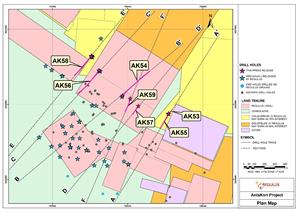
Figure 1 - Plan Map showing the location of drill hole collars and traces
Figure 2
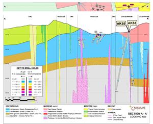
Figure 2 – Cross Section displaying holes AK-22-053 and AK-22-055
Figure 3
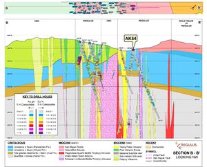
Figure 3 – Cross Section displaying Hole AK-22-054
Figure 4
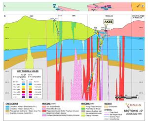
Figure 4 – Cross Section displaying Hole AK-22-056
Figure 5
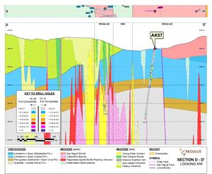
Figure 5 – Cross Section displaying Hole AK-22-057
Figure 6
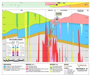
Figure 6 – Cross Section displaying Hole AK-22-058
Figure 7